Some more images of Old St Peter’s basilica in Rome

This evening I did a Google Images search for images of Old St Peter’s basilica in Rome.  I’ve put some of these online before; but it’s always worth searching again, as new material appears all the time.

Note that you can click on these images to get a larger picture sometimes.

Via this site I learn of the existence of a map of Rome by Etienne du Perac (1577); curiously not from the text, but by inspecting the HTML source for the page!  Here’s a detail of it, highlighting the fountain that stood in the atrium:

pianta di Roma di Etienne Du Perac (1577), particolare del Vaticano.
Pianta di Roma di Etienne Du Perac (1577), particolare del Vaticano.

The same site also has a drawing of the fountain from somewhere, made anonymously ca. 1525.  One would like to know where this clearly well-informed website got its information!

La fontana di San Pietro, in un disegno a penna di anonimo del 1525 c.ca.
La fontana di San Pietro, in un disegno
a penna di anonimo del 1525 c.ca.

The huge brass pine-cone still stands in a courtyard in the Vatican, as those who have done the tour well know.  I wonder whether the item has any connection with the cult of Cybele, for a Phrygianum once stood somewhere on the hill, as the 4th century regionary catalogues indicate, and a bunch of 4th century inscriptions from it were dug up near the piazza outside new St. Peter’s.

Next let’s have a drawing of the construction of new St Peter’s.  The remains of the old nave stand to the left here, for this is a shot of the hulk of the new basilica from the north side.  The author is Martin van Heemskerk, in 1536.

Van Heemskerk, Construction of basilica, 1536.

Now another drawing (caution – the site plays audio at you!), this time showing the construction from the west.  The pointy tower on the front of the old basilica still stands, with some of the nave behind it.  But to the right is a circular building; the chapel of San Andreas, or “Vatican Rotunda”, a 3rd century tomb converted into a chapel.  And is the tip of the Vatican obelisk just visible beyond it?

Costruzione-San-Pietro-630x300

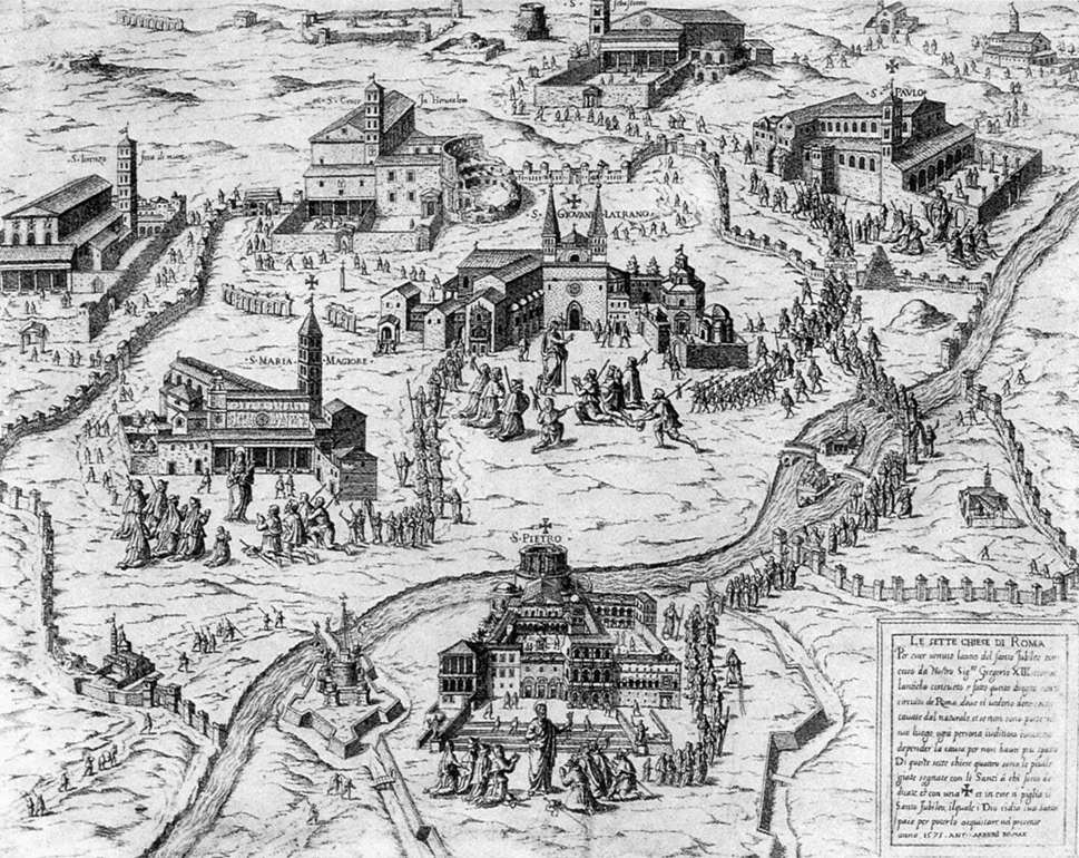
Now here’s another overview shot.  This, I learn from Anna Blennow – thank you! – is a detail from Antonio Lafreri’s image of the seven churches of Rome, 1575, here.  The surroundings of the church are not accurate, but the general layout is.  It shows the Vatican rotunda, just to the left side of the nave, with the atrium – and fountain – behind the raggedly front facade.

basilica_costantiniana_scomparsa_prima_basilica_di_san_pietro_(città_del_vaticano)

I also found online a picture of a model from the Vatican museums, although it was back-to-front on the site on which I found it!  It shows the Vatican rotunda, with the obelisk before it (although not the surrounding houses); and also the other 3rd century tomb behind it, the chapel of S. Petronilla, in which the Empress Maria, the young wife of the Emperor Honorius, was buried.  That tomb was demolished very early in the rebuilding, and the grave of the empress found and emptied.

vatican_museum_model

However the most exciting pictures are some colour paintings that had previously passed unnoticed.  The first is a painting of the burning of the Borgo, a district nearby, by none other than Raphael himself!

Raphael, The burning of the Borgo, detail.

In the background is the tower, and to the left of it, the facade of the main church inside the atrium!  This, as we shall see, was indeed painted yellow, with pictures on it.  Ste Trombetti kindly drew my attention to this site, which zooms in yet further:

Raphael, Burning of the Borgo, more detailed

This shows the pope in the tower, and the church behind (not sure that all the elements are in their real and historical places here; but we don’t care, because we get these marvellous pictures).  The image of the stonework in particular gives a sense of scale otherwise difficult to sense in many of the old pictures.

The next image, a fresco from the sacristy in the modern Vatican, from Art Resource gives us a sadly low-resolution image of the exterior of the old basilica, which lines up very nicely with Raphael’s depiction (a high res image can doubtless be purchased at that site).

The atrium and entrance to the nave of old St Peter's.
The atrium and entrance to the nave of old St Peter’s.

Finally, also from Art Resource, is another image from the Vatican museum, this time with an unusual “head on” view of the outside of the basilica.  It shows the coronation of Sixtus V in 1585  A larger image of this would be very welcome!

Coronation of Sixtus V outside Old St Peter's.
Coronation of Sixtus V outside Old St Peter’s.

That’s it for now.  Many thanks indeed to Ste Trombetti and Anna Blennow, who saw these images being posted on Twitter and contributed their better images!

Share

The Bufalini map of Rome (1551)

Old maps of Rome can contain very useful information.  At this site is the 1748 reproduction of the 1551 Bufalini map of Rome.  The original is here, but for some strange reason is upside down and nearly unreadable.  (Both sites have annoyingly provided us with a “viewer” rather than a download of the whole map).

Let’s look at one or two locations.  The first is to look at St Peter’s:

Buffalini (1551) - Plan of Old St Peter's
Buffalini (1551) – Plan of Old St Peter’s

The “Templum S. Petri” has the modern plan at the western end, but the Old Constantinian basilica at the East, leading into the atrium, then down some steps and into the “Forum S. Petri”.  The Palace of the Pontiff faces into that piazza, which can be entered from the north through the wall that runs east to Castell S. Angelo.  The same entrance in the wall into St. Peter’s square is used by modern visitors, coming from the metro station.

A circle at the bottom of the “new” portion indicates the location of the Vatican rotunda, a 3rd century tomb converted into a chapel and only demolished a couple of centuries later.  To the right of it is a speck, which is the Vatican obelisk that now stands in St Peter’s square but then stood where it had stood for centuries, on the spina of the vanished Circus of Gaius and Nero.

There are various renaissance depictions of all these monuments online, and elsewhere on this site – click on the link for “Old St Peters” at the end of the post – but a map is invaluable.

Next let’s look at the area to the south of the Colosseum:

Bufalini (1551) - Location of Septizonium and Meta Sudans
Bufalini (1551) – Location of Septizonium and Meta Sudans

The Colosseum is next to the Palatine hill; but note the little shaded rectangle to the left of “Septizonium Severi” at lower centre.  That is the location of the remains of the Septizonium, the monumental arcade-entrance to the Palatine, built as a facade by Septimus Severus and demolished only a few years later than the map.  And to the left of the Colosseum is the dot marking the fountain, the Meta Sudans, which survived until Mussolini demolished it in the 1930’s.

Off to the right of the Colosseum, and beyond the church of S. Clemente, are the immense ruins of the Baths of Titus (Thermae Titi):

Bufalini (1551) - Baths of Titus
Bufalini (1551) – Baths of Titus

Let’s now wander off to the Quirinal Hill, up and left.

Bufalini (1551) - Temple of the Sun
Bufalini (1551) – Temple of the Sun

Somewhere in those streets is the modern Trevi Fountain.  But in the centre is the now vanished remains of the Templum Solis Aureliani – Aurelian’s Temple of the Sun.  Below it and to the right are the Baths of Constantine, the last major bath complex of imperial Rome.

I hope you have enjoyed your ramble around a vanished Rome.

(H/T Anna Blennow)

Share

Another image of the Vatican rotunda

In the modern basilica of St Peter’s in Rome, the high altar is at the west end. The same was true of the basilica built in the 4th century by Constantine.

By the south door of the basilica stood two large round buildings, which ran in a line west-east.  The western-most of these was demolished as part of the construction of the new basilica, but the other stood until the 18th century, when it too was demolished. It is sometimes known as the Vatican rotunda.

To the east of them both, on the same line, stood the Vatican obelisk.   This item from ancient Egypt now stands in the piazza before St Peter’s.

The following 19th century reconstruction, depicting a magnificence that the old basilica probably never possessed, indicates what was where:

rotunda_location

Another image of the Vatican rotunda has reached me.  This time it appears in a painting by Giorgio Vasari (d. 1574), “Pope Paul III Farnese directing the continuance of St Peter’s”, available here.  A detail of this shows the new basilica under construction, the Vatican rotunda to the right, and the obelisk (surely in the wrong place?) beyond it.

Giorgio_Vasari_-_Paul_III_Farnese_Directing_the_Continuance_of_St_Peter's_-_WGA24304
The rotunda was clearly not a particularly attractive building.  It looks as if it was a vast circular building, on top of which a structure with windows had been constructed.

One reason why the rotunda was so simple is that it was probably, originally, a massive, circular 3rd century Roman tomb.  The land around it was raised by Constantine’s architects, in order to provide a platform for the basilica; and the obelisk ended up with its lower section underground.

The archaeology clearly indicates that a circular building was constructed on this site in the early 3rd century, in the Severan period.  It is not quite clear whether the rotunda is the same building, or a replacement on the same site at a somewhat higher level.

The obelisk stood on the spina of the Circus of Gaius and Nero.  The presence of tombs on the same site indicates that the circus had gone out of use in the same period, as the Vatican cemetery spread down the hill towards it.

The archaeology is not as clear as might be desired, because the site can only be excavated with small pit trenches.  So there is much uncertainty in all this.

Share

Rome in 1557 – Old St Peters, the Septizonium, the Templum Solis

Another marvellous find by @ste_trombetti at the Bibliotheque Nationale here;[1] – a large map depicting Rome in 1557!  Here is an excerpt (click on the image to see it all)

recens_rursus_1557_excpt

 I have ventured to highlight, in this excerpt, three monuments, all now vanished.  Near the Palatine, the remains of the monumental entrance to the Palatine, known as the Septizonium.  On the Quirinal hill, the remains of the Temple of the Sun.  And, over on the Vatican, the Constantinian basilica of Old St Peter’s, with the circular centre of the new basilica arising at the west end, and the obelisk still in its original position on the south side (for St. Peter’s, remember, faces east, rather than west as modern churches do).

Share
  1. [1]Recens rursus post omnes omnium description. urbs Romae …; Éditeur : Formis Anton. Lafrerii (Rome); Date d’édition : 1557; Type : image fixe,estampe; Langue : Italien; Format : 1 est. : en coul. ; 35 x 47 cm

Plans and illustrations of the Vatican from 1694

We’ve been looking at old pictures of Old St Peter’s in Rome, and thinking about the Circus of Nero nearby, and other structures from ancient Rome.

Last week Brent Nongbri very kindly sent me an extract from one of those tourist books, which the Italians do so well, about the pagan tombs under the Vatican, which contains some interesting diagrams.[1]  In it, my eye was drawn to some splendid old pictures, which the author had reproduced from Carlo Fontana, Il Tempio Vaticano e la sua origine, Roma, 1694.[2]

The book is mainly about New St Peter’s.  It has details of how the Vatican obelisk was moved (with pictures!).  But it also contains plans and reconstructions of the older basilica, and the area around it.  I thought that these would be known to few, and deserved to be better known.

Here are some of them.  Click on the image to get the full-size picture.  (They’re all small)  I apologise for the cut-off to the right; the blog software doesn’t handle this very well.

Plan of the ancient Vatican area.
fontana_2_plan
Plan of Nero’s circus and its relation to the basilica.
fontana_3_circus_of_nero_w_petronilla
Reconstruction of Circus of Nero with dome of “temple of Apollo”, later Mausoleum of Honorius, later still chapel of St. Petronilla.
fontana_4_plan_of_old_basilica
Plan of old St Peter’s, with New St Peter’s and the Circus of Nero all on the same plan.
fontana_5_section_of_old_basilica
Section lengthways through Old St Peter’s.
fontana_6_half_built_w_andrea
St Peter’s halfway rebuilt, from the south; the new circular church, the Vatican rotunda, and behind it most of the old church.
fontana_7_grottos_of_vatican
Plan of the cellars under the Vatican.
fontana_8_section_and_end_of_old_basilica
Section through Old St Peters side-ways, with picture of the old frontage.
Share
  1. [1]Pietro Zander, The Necropolis under St. Peter’s Basilica in the Vatican, Elio de Rosa editore, 2009.
  2. [2]Online at Archive.org here, from the original, rather strange, Microsoft digitisation; a better version at Heidelberg here.

Bits and pieces on the Circus of Nero

Today I came across this picture here, clearly of a model, of the “Circus of Caligula / Circus of Nero” on the Vatican.  Whether the two circuses were indeed the same I do not know.  But the model-maker was clearly aware of the construction of a large circular building on the spina of the circus in the Severan period, which tooks terribly out of place in the model.  The ground level was artificially increased by something like 15 feet, and apparently the circular church of St Andrew had a basement level.

Anyway I thought that I would share the image with you.  I wonder where it comes from?

Model of Nero's circus, Vatican
Model of Nero’s circus, Vatican

Another interesting drawing from here:

circus_of_nero

And a 1911 map of Rome by Platner from here, showing the supposed location of the circus:800px-The_Topography_and_Monuments_of_Ancient_Rome_QNONote that I have now found an account of the modern excavations, by F.Magi, from which the “modern” plan of the circus derives, here.[1]

Share
  1. [1]John H. Humphrey, Roman Circuses: Arenas for Chariot Racing, University of California Press, 1986, p.545 f.; on p.683 n.29 the article is given as F. Magi, “Il circo Vaticano in base alla piu recenti scoperte, il suo obelisco e i suoi ‘carceres’, Rendiconti della Pontificia Academia Romana di Archeologia 45, 1972-3 [1974], 37-73.  This also  gives the “Castagnoli” reference: F. Castagnoli, “Il circo di Nerone in Vaticano”, RendPontAcc 32 (1960), 97-121.   The Humphrey book can be read with difficulty at the UC Press website here.

Old St Peters, the Circus of Caligula and the Phrygianum

The Vatican hill is famous today for the great basilica of St Peters, constructed in the third decade of the fourth century by Constantine, and demolished and rebuilt in the 16th century.  A collection of essays on this building appeared in 2013, edited by R. McKitterick,[1] which contains various interesting snippets.

St Peters basilica in Rome in the early sixth century
St Peter’s basilica in Rome in the early sixth century

Few today are familiar with the layout of the church, so the diagram at the side is useful.  A flight of steps led up to a gatehouse, behind which was a courtyard.  This later contained the immense bronze pine-cone now in the Vatican museum.  Behind this was the church proper, with a nave and two aisles.  The transept gave access to two circular structures, the mausoleum of Honorius (which was turned into the chapel of St Petronilla during the early Dark Ages) and the chapel of St Andrew.

Around the church were all sorts of structures, not depicted on this diagram.  The church was the constant resort of beggars, seeking alms, and doubtless many of the dwellings were hovels.  Theodoric ordered the distribution of grain to them in the late 5th century; Pope Symmachus had shelters constructed for them near the church, and the Dialogues of Gregory the Great record a crippled girl who more or lived in the church until she was healed by a miracle.[2]

A plan of the church by Alfarano, who had been associated with the church since the 1540’s, was published as an etching by Natale Bonifacio in 1590, when construction on the western end of the new basilica was well advanced.  It shows the new construction as a ghost under the old.

Tiberio Alfarano drew the plan in 1571, and the hand-drawn original, known as the Ichnographia, is extant in the archive of the Reverenda Fabbrica di San Pietro.   Comparison shows that the printed version tinkered with the original in various ways, and that not every architectural feature on the drawing appears in the etching.[3]

1590 plan by Alfarano of Old St Peters

On the south side of the basilica were two circular structures, the chapel of St. Petronilla, actually the Mausoleum of the emperor Honorius; and the chapel of St. Andrew.  Beyond these was the obelisk which now dominates St Peter’s square.

The function of the structure as a mausoleum was remembered as late as the 8th century, but thereafter forgotten until 1458 when a splendid late Roman burial was discovered under the floor, possibly of Galla Placidia and her child.  Another was found in 1519, and finally in 1544 the intact sarcophagus of the empress Maria, wife of Honorius, complete with 180 precious objects in two silver chests, all of which were dispersed or melted down.  The depiction of the basilica in the Nuremberg chronicle of 1493 depicts a round, squat building, which was doubtless the mausoleum.

The structure to the east of it, labelled “Vatican rotunda” in the plan, must predate the basilica as it appears in a gem of the 3rd century.  It was converted by Pope Symmachus in the 5th century into a chapel of St Andrew.[4]

Plan of the mausoleum of Honorius.

I have also seen a paper suggesting that the “mausoleum of Honorius” was itself a 3rd century tomb, as was the Rotunda di Sant’Andrea.  The mausoleum was demolished during the building of New St Peter’s, but the Rotunda remained until the 18th century, becoming the church of Santa Maria della Febbre.  A 1629 painting of it, still behind the obelisk (which was surely moved by then?) and with New St Peter’s half-built behind it is available online:

Rotondo di Sant'Andrea, Vatican, Rome.  1629
Rotondo di Sant’Andrea, Vatican, Rome. 1629

And another 18th century drawing by Piranesi[5] shows it nestling next to the basilica, when it was used as a sacristy[6]:

18th century Piranesi drawing.

The obelisk is an interesting feature, since it is quite unlikely that it was placed there by Constantine.  We learn from Pliny’s Natural History that Caligula erected an obelisk from Heliopolis on the spina of his Circus, in the Horti Agrippinae on the Vatican.[7]  There is apparently consensus, among interested scholars, that the only certain fact about the location and orientation of the circus is that this obelisk was in the centre of it.[8].

Two different circus plans appear online.  I don’t know the source of the second one.[9]

old-st-peters-circus-plan2

old-st-peters-circus-planWhat can be said with certainty is that material from the circus was found during excavations in St Peter’s square, some 5 metres down.[10]

Somewhere nearby, in all this, is the temple of Cybele and Attis, the Vatican Phrygianum.  That such a temple existed in 160 A.D. is recorded by an inscription from Lyons which reads:

Taurobolio Matris d(eum) m(agnae) I(daeae) / quod factum est ex imperio ma tris deum /pro salute imperatoris Caes(aris) T(iti) Aeli Hadriani Antonini Aug(usti) Pii p(atris) p(atriae) / liberorum eius /et status coloniae Lugdun(ensium) / L(ucius) Aemilius Carpus IIIIIIvr Aug(ustalis) item / dendrophorus / uires excepit et a Vaticano trans/tulit ara(m) et bucranium /suo inpendio consacrauit / sacerdote / Q(uinto) Samnio Secondo ab XVuiris /occabo et corona exornato / cui sanctissimus ordo Lugdunens(ium) perpetuitatem sacerdoti(i) decreuit / App(io) Annio Atilio Bradua T(ito) Clod(io) Vibo / Varo co(n)s(ulibus). [11]

Various inscriptions from the end of the 4th century consist of dedications to Cybele by the last holdouts of the pagan aristocracy, suggesting that perhaps the temple was still in use in this period, and recording that the ritual of the taurobolium – being bathed in bulls’ blood – was taking place here.

Pensabene states that the 1959-60 excavations by Castagnoli – I don’t have a reference for these – revealed that there were major works in this area during the Severan period.  The ground level was artificially raised by several metres and a large circular building was constructed whose foundations were contiguous with the obelisk.  The foundations  of this building contained Severan stamps from the first quarter of the 3rd century A.D. The suggestion is that this was to allow the building of a new Phrygianum, and that this was done under Elagabalus, who was enthusiastic for the cult.

The text is accompanied with a very poor quality image which appears to suggest that the Rotonda di Sant’Andrea stands on the site of the Phrygianum, and that the building was originally circular, with a south-facing portico:

old-st-peters-phrygianum

My Italian is not good enough to work out whether Pensabene is suggesting that the Rotondo was, in fact, the carcase of the Phrygianum, stripped of its portico and reused for something else.   But if so, this would certainly be very cramped, next to the basilica, and the presence of the vile eunuch priests and their revolting sacrifices right by the south door sounds rather unlikely to me.  Even if it was a state cult, which Constantine might have been unwilling to interfere with, this seems improbable.

So where was the Phrygianum, if not here?

Share
  1. [1]R. McKitterick, Old Saint Peters, (British School at Rome Studies), 2013.  “Look Inside” on Amazon here.
  2. [2]For these details I am indebted to Paulo Liverani’s paper “St Peter’s and the City of Rome” in the McKitterick volume, of which I was able to read parts via the Amazon “Look Inside”.  The material may be found on p.26; Gregory, Dialogues I, 3.25.1, 108; Life of Symmachus, 53, c. 7, in the Liber Pontificalis I 262; Theodoric in Procopius, Anecdota 26.29.
  3. [3]These details appear in the front matter of the McKitterick book, whose footnotes were sadly inaccessible to me.
  4. [4]Meaghan McEvoy, “Chapter 6: The mausoleum of Honorius” in: R. McKitterick &c., p.119 f.  Accessible via Google Books preview here.
  5. [5]Via Wikimedia Commons
  6. [6]See Italian Wikipedia article here.
  7. [7]Plin. NH XVI.201; XXXVI.74; CIL VI.882 = 31191.  All these references I owe to a remarkable discussion in the Ancient Coins forum here.
  8. [8]Patrizio Pensabene, “Culto di Cibele e Attis tra Palatino e Vaticano”, Bollettino di Archeologia 2010, Online at http://www.archeologia.beniculturali.it/pages/pubblicazioni.html; except that, at the time of writing, this is offline and I was only able to access the article via the Google cache.  UPDATE: Later I found it at Academia.edu here.
  9. [9]The first is from R. Lanciani, Pagan and Christian Rome, 1892,  and appears on Wikimedia Commons here.  Both have been copied from here.
  10. [10]Or so it claims on this website; it would be interesting to have proper details of these excavations.
  11. [11]CIL XIII, 1751. 

More on Old St Peters in Rome

This morning I found some more material of interest about Old St Peters in Rome.

Firstly, I found a rather good line-drawing of the appearance of the church here.[1]

oldstpetersdiagramThis is really helpful in trying to visualise Constantine’s basilica.

The “atrium” at the front looked like this (drawing by G. Grimaldi), although normally it must have been full of people.  The murals on the wall of the church were medieval.old_st_peters_grimaldi

A partial map is here:

old_st_peters_alfarano_mapBut I learn that a detailed set of drawings and plans was made by Martino Ferrabosco, just before the demolition of the old church.  His very detailed and labelled plan is here (warning: the zoomable online reader caused my eyes to malfunction for 10 minutes with flickering zigzag lines):

old_st_peters_ferrabosco_plan

And the following image is a detail from an image in the Nuremberg Chronicle (1493):oldstpeters_1493

I wonder where the Ferrabosco dossier is?

UPDATE: It seems that Martino Ferrabosco published Libro de l’Architettura di San Pietro in 1620.  An article (in Spanish) about it is here.

Share
  1. [1]The source URL given on that page has vanished, so I don’t know the source of it.